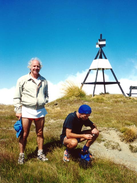
Charles Semple and Tony Larkum
on the Mt Fyffe traverse
NOTE: This website is now a bit out of date: For the best list of >500 trail runs across NZ go to Mal and Sally Law's excellent Wild Things - NZ Trail Running Club website.
Mountain running is a cross between running and alpine tramping. By travelling light and fast, and choosing a fine day, you can do trips that would normally take several days to hike, and get some good exercise along the way! Apart from fitness, you should have good route-finding skills, and know about things like hypothermia, dehydration, rock-fall, river crossing etc.
Note: Most of the trips described here are round trips, but if it the weather changes suddenly (eg. southerly front) you may need to turn back, or escape quickly off an exposed ridge. All these runs are in NEW ZEALAND (except for the last two in Austria/Germany); mostly in the south island (and many near Christchurch, where I live). For most trips below all gear will fit in a camelback or bumbag (select one with tensioning straps); for a few of the longer/more committing runs the combination of both is useful (so too is small quantities of sunblock and vaseline, a varied selection of food, short toenails (!), plenty of carbs the night before, and for breakfast, an mp3 player, electrolyte drink powder, and in case of mishap a small roll of sleek tape, painkillers, pocket-sized space blanket).
Below are some examples, then some others that are also good, and some more runs specifically close to Christchurch (good ones get a star). Please send me any feedback or other runs that would be good to add/try out.
|
Charles Semple and Tony Larkum |
As a day run, these trips should only be attempted in good weather and when they're clear of snow (early summer to autumn). Take a wind/waterproof jacket, map, compass, water, sunblock, etc. Stars indicate quality of the route.
 A pleasant and spectacular outing with a good mix of terrain. Have done this one many times - takes about 4.5 hours. From the car park at the end of Postmans road (15 mins drive from Kaikoura), jog up the 4wd road to the hut (usually water) and then to the summit of Mt Fyffe (total~1.5 hours). From here it's a superb run north (see the pic at the top of this webpage) following occasional markers along the undulating tops towards the Kowhai saddle (particularly scenic in late spring or autumn). Cross an obvious level narrow col with scree runs on both sides (but avoid the temptation to descend the scree that starts at the prominent narrow section before the last rise, unless you like waterfalls, and adventure!) and follow the track up the next hill `Gables end') and traverse along to where the descent to Kowhai saddle starts. Follow markers down to the saddle (good running), or else a short distance before take a fast descent down a long soft steep scree slide, that ends with a short steep rocky and scrubby descent for the last bit into the upper Kowhai river where you rejoin the "track". The first bit is slow going down the bouldery river bed (tricky if there's snow or it's wet) with occasional trails through scrub on the true right. However watch for marked tracks (orange markers) mostly on the true left that lead through extensive sections of bush. In this way you can stay out of the river for most of the way down. Eventually you'll arrive at and cross main Kowhai river that flows down from the big mountains, and climb onto a terrace where the track soon arrives at Kowhai Hut. From here it's a very cruisy 1+ hour run down valley - following a clear trail you cross the river and then follow an obvious track through bush on the true left. A short open section leads to a trail that appears to run out, however on your left is an unexpected orange marker showing the start of the second tracked section which leads to near where the valley closes into a gorge. From here you are in and out of the river criss-crossing the gorge (trails allow you to take a fairly straight line) beyond which a trail on the true right leads into another fast bush section. The riverbed after here is easy running (with 4WD trails). At the corner where the valley finally opens out, and past the bluff on the left, head back to the true left and run towards the open scrub beside the hill - here you will pick up a track (marked) that leads onto a 4WD drive tack and brings you back to the car park.
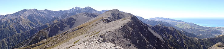
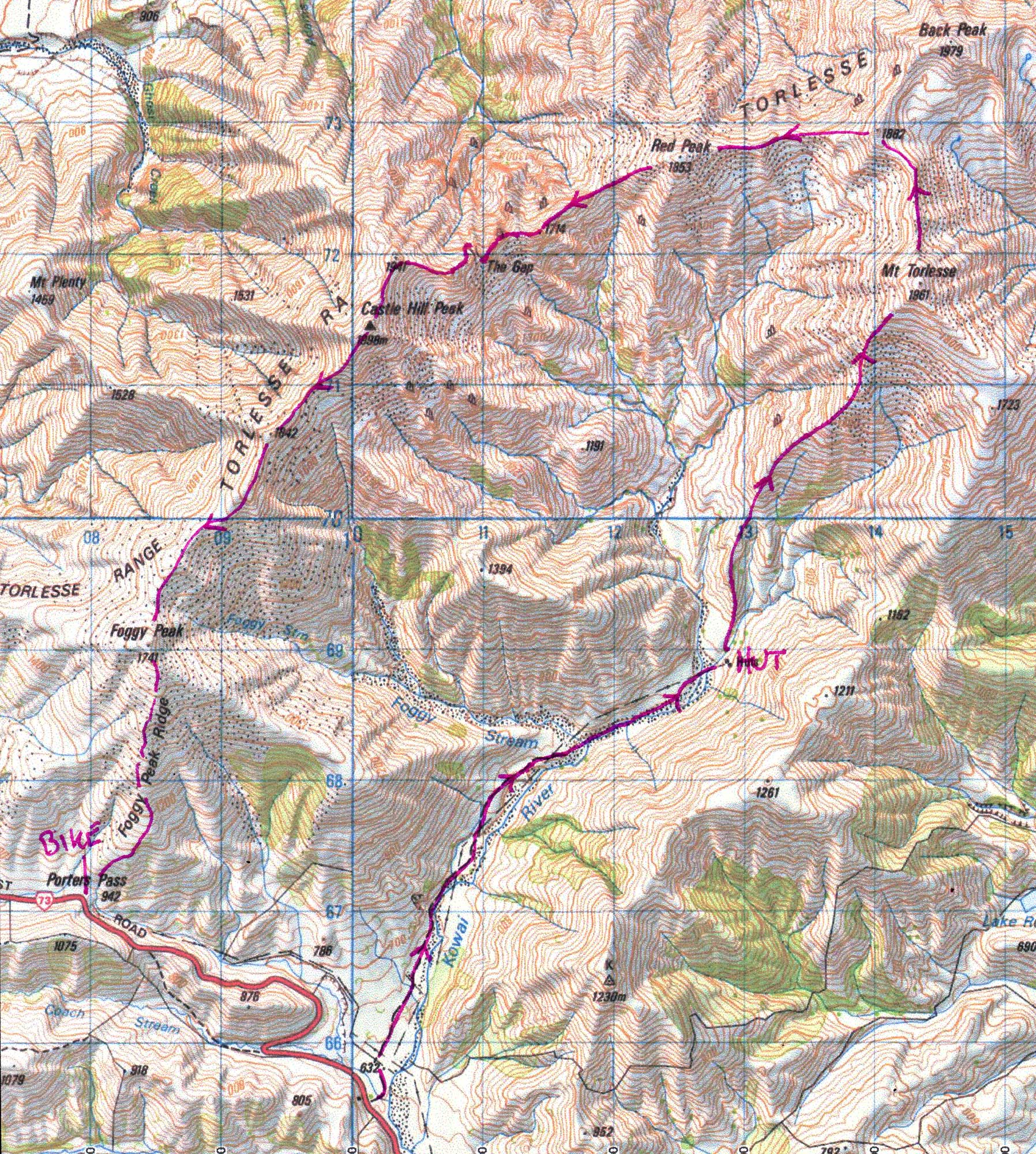 A great summer-time mountain run along the top of the Torlesse range (with views to Arthurs Pass, Mt Cook etc), with a refreshing downhill bike descent at the end. It's a day trip from Christchurch, but start early. If solo, there's FM reception from Christchurch for most of the trip. Takes 5 hours+
Drop a bike on the top of Porters Pass (1 hr west of Christchurch) then drive back down the pass and park in the first prominent layby on the left. Run up the Kowhai river valley track to the hut. Fill up from the stream, and climb the prominent ridge that begins just behind the hut and leads relentlessly up to the summit of Mt Torlesse. From here it's a fast scree descent and undulating climb around to Red Peak then a long climb up to Castle Peak - this section has some interesting rock scrambling before and around the impressive "gap" in the ridge (at the gap drop east down a steep gully, go through the gap, then traverse west to regain the ridge via steep slabs). From here it's a cruisy run all the way (except for a short climb up over Foggy Peak), with a long descent down to the pass to pick up the bike. Refreshing blast down the hill - don't do this trip in reverse! Nice chicken and camembert pies at the Springfield pub.
Although not overly remote, this circuit goes through some amazing goblin-like limestone landscape, with caves, sinkholes, bush, streams, and great views along the way. Park at the Flora saddle information centre, and run to nearby Flora saddle. Can be done in either direction. CLOCKWISE DIRECTION: Take the direct track to Mt Arthur Hut then on to the summit of Mt Arthur (1795) following the poled route. From here descend down the unmarked north ridge (if thick cloud sweeps in, maybe retrace to the side track that heads across horseshoe basin). Either way you'll end up on the poled route that leads over Gordon's pyramid to Salisbury Lodge (the side trip via Sphinx stream and potholes is worthwhile). Don't take the 'shortcut' out via Cl. Mine which is said to be overgrown. From Salisbury Lodge it's a fast 10km gently downhill across the open Mt Arthur tablelands then bush, and then a gentle but steady uphill for 5km to Flora hut, and a short final ascent to Flora saddle. Map M27 (Mt Arthur) may be useful. Approx. 30 km, takes 4.5 hours including lunch and views. ANTICLOCKWISE: This has some steeper 'up' sections that you'll be walking, but is possibly a better option if the weather is settled and it finishes with a superb 1 hour descent to the car rather than the slog up to Flora saddle.
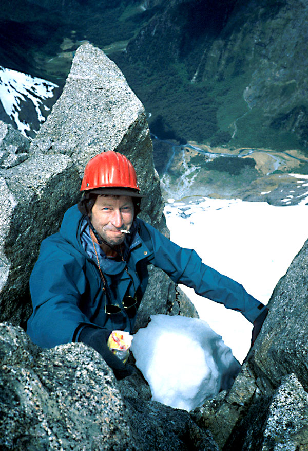
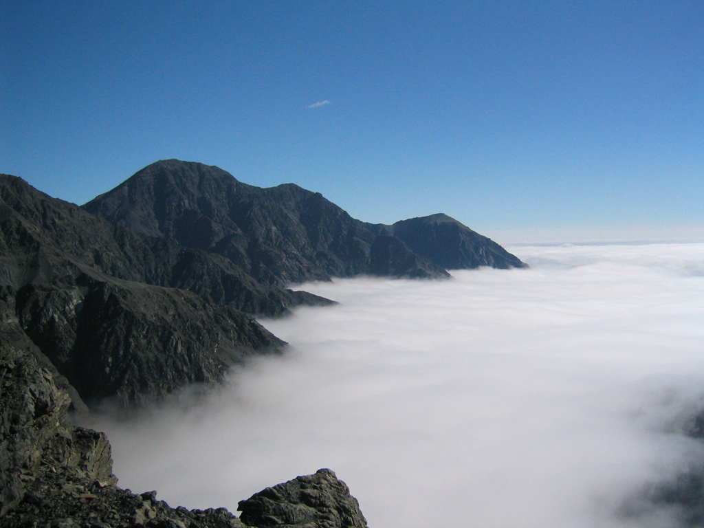
James Shanks enjoying the view in Fiordland |
It is legal to run the Milford track at anytime, in any direction, and without asking anyone for permission (i.e. it is a public track in a national park, and booking system applies only to the huts), however you may wish to talk to DOC (Te Anau) first; also be sure you're fit enough to do this trip as you will be unpopular if you get into trouble on the track. Make sure the forecast is good and that Dore Pass is clear of snow before you start! This means it's mostly possible only around summer. Put a tent and bike at Smithies Creek campsite (50km from Milford sound) and arrange for someone from Roscoe's Sea Kayaks (Milford Sound) to drop you off the next day at Sandfly point at around 6am (cost is negotiable +some beer for dragging them out of bed so early). Once they've buzzed you across (10 mins) run the Milford track (53+ km) which is rated as one of the most spectacular walks on the planet (normally done over 4 days, and often booked out a year in advance). Any walkers will be coming towards you - give them right of way, and treat them with respect and discretion! Some swimming holes towards the end to cool off in. At Glade house tank up with food (can't be purchased - carry from the start!) and drink then start the big climb up over Dore Pass (rated a difficult 5-8 hour tramp). The track begins near the hut's washing line; watch for the marker and stream crossing after the first short climb. There's a high traverse south on the Glade side, and significant routefinding on the Eglington valley side (could be tricky in cloud or the dark) - take a map/compass and read Moir's guide. The route down the Eglington valley side is initially on the right of the valley, but crosses to the left where the open spurs lead down to the first gorge; towards the end of this level scrub section cross the stream to a track in the bush on your right - it's essential to pick up these crossings along the faintly marked trail. Stay at the tent then complete the circuit by biking back to Milford sound the next morning (spectacular ride, especially the 14km downhill blast starting from the Homer tunnel). An easier, but perhaps less satisfying option is just to run the Milford Track and catch the last boat back to Te Anau downs.
 Two excellent fine-weather/summer circuits from St Arnaud that each traverse Angelus Peak in different directions and in quite different styles. Each start at the well-marked track that leaves the Mt Robert road a km or two after it crosses the Buller river (well before the Mt Robert carpark). Finish in the same spot or at the nearby St Arnaud DOC campground where there are hot showers for 2 dollars. Other variations are possible also, including perhaps the Speargrass track or the entire Travers-Sabine circuit.
Adventure Option: Angelus ridge
This trip includes a traverse of the prominent east ridge of Angelus peak. It wasn't until the 1960s that anyone traversed the full ridge, but it is now recognized as an excellent summer climb that can be soloed with care (alpine grade 2+); mountain running shoes are fine.
 Run up the track that takes you round the west side of Lake Rotoiti to Coldwater hut, and on to Hukere stream (1-1.5 hours). Cross the bridge over this stream, fill up with water, and strike out into the forest heading for the prominent ridge that rises up to separate the Travers river and Hukere stream. The steepening ridge is easily followed through the bush, and climbs to a rock band at the bushline which requires some care. Beyond this the ridge has pleasant and varied travel until pt 2015 is reached. Drop into the scree between here and pt 2037 and regain the ridge to bypass some difficult obstacles that would require a rope. Carry on over pt 2093 and descend carefully (tend right near the bottom) to the major col that overlooks screes into the Hukere and Hopeless head-waters (possible escape options - as is the earlier descent down steep scree to Hopeless hut). The section from here to the summit of Angelus Peak has the most 'interesting' and at times airy rock scrambling; it takes much longer than it looks on the map! From Angelus Peak, drop down to the attractive alpine basins and the hut by Lake Angelus. From here it's an excellent 2 hour run along a well-marked track over the undulating tops (great views) and down via the Bushline hut track back to the bike/car.
Standard route: Angelus-Hopeless or Angelus-Hukere
This run might lack the sense of adventure of the previous option but it combines much of the scenery of the previous trip with terrain that is much easier to run since it's virtually all on trails. Run a short distance along the track and take the track that climbs steadily but runnably up to Bushline hut and continue on to join the main track that leads along the long undulating tops to Angelus hut. Drop down to cross the outlet of the tarns and climb the easy north ridge of Mt Angelus. Descend to sunset saddle and drop down between the tarns and descend out (true) right to avoid bluffs below - once in the head of the Hopeless valley pick up the trail on the right and run out via the Hopeless and Travers valleys to the Lake (A shorter alternative is to return from Angelus peak via the Cascade track and Hukere stream). Depending on where you want to finish you can run either way round the lake.
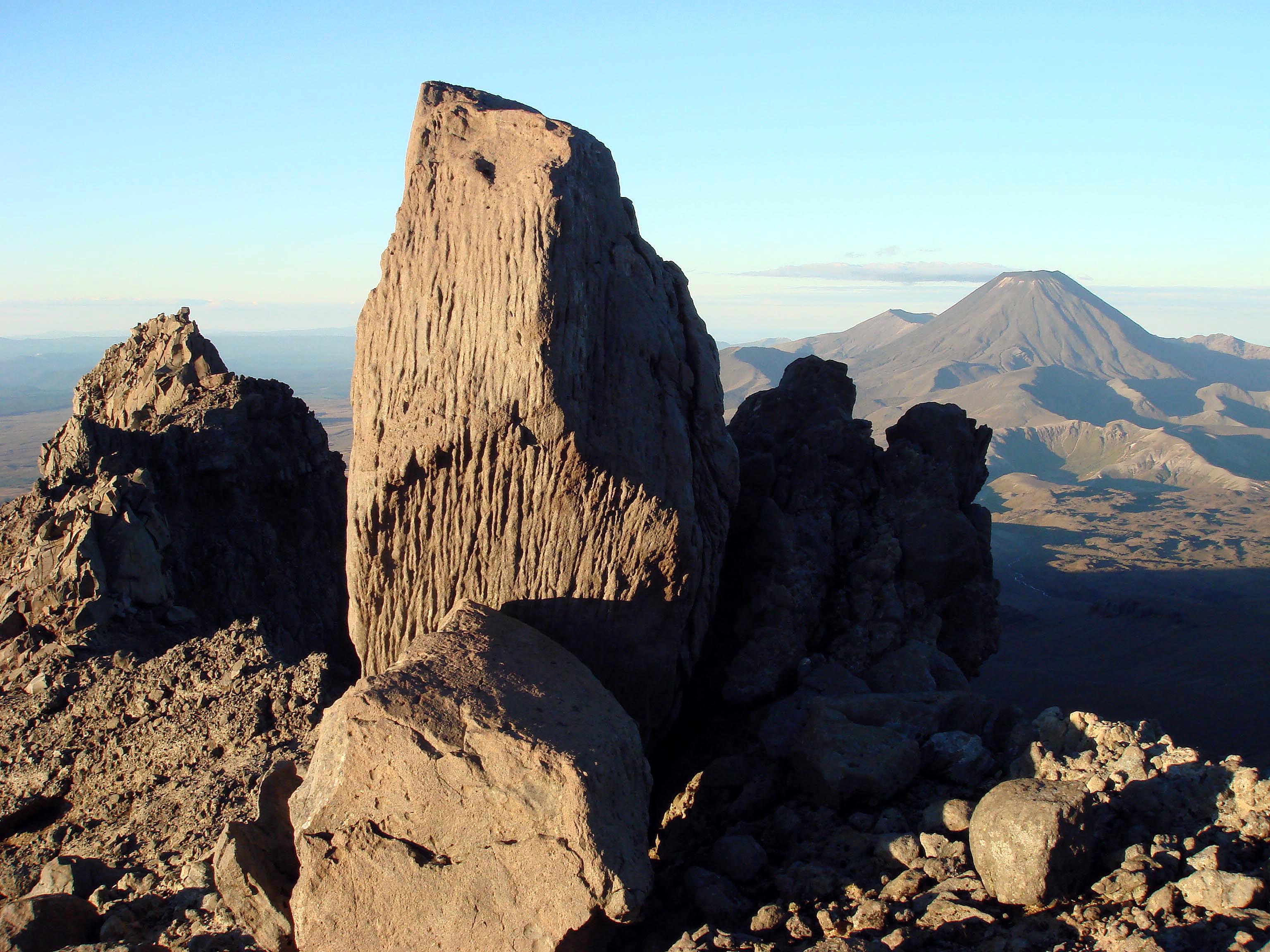
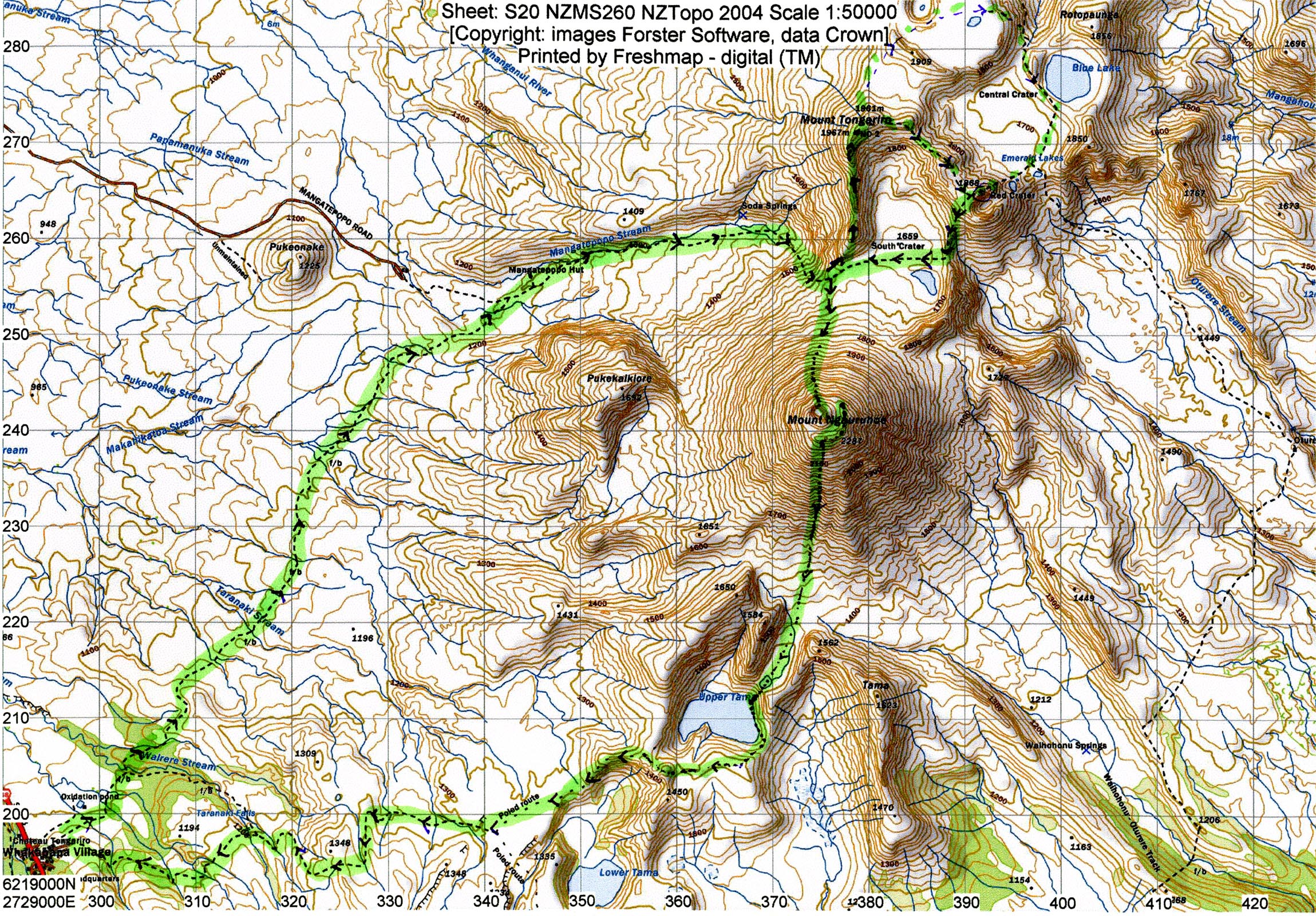 This superb circuit traverses mounts Tongariro and Ngaruhoe on a variety of terrain (some of it untracked) from Whakapapa; very spectacular on a fine day and the added bonus of a swim on a sandy beach (!) en route. If cloudy the `Northern circuit' is a good back-up option -- see below. Take a jacket, plenty of water and start early. Approx 30 km, 5 hours. From the Chateau/Skotel, head out on the track to Mangatepopo hut (1 hour) then continue on the Tongariro crossing up to the top of the devil's staircase. Leave the track and strike out north on top of the untracked ridge up Mt Tongariro (this ridge dominates the skyline all the way up the Mangatepopo valley). The ridge has some nice rock scrambling in places. From Tongariro summit run back down the tracked ridge to Red Crater (or possibly traverse further north cross country to take in the north crater/blue lake/emerald lakes, joining the Tongariro crossing near Blue lake, but this involves climbing back up Red Crater). From Red Crater run back along the Tongariro Crossing track to the trail that leads up Mt Ngaruhoe. Climb this volcano by using as much of the descending rock band as possible (600m, 40 mins). After checking out the inner crater, return north-east to the steaming outer rim, and run around to the high point on the far (Ruapehu) side of Mt Ngaruhoe, then drop off the edge (no trail) -- take a bearing on the upper Tama lake and begin the steep, airy
 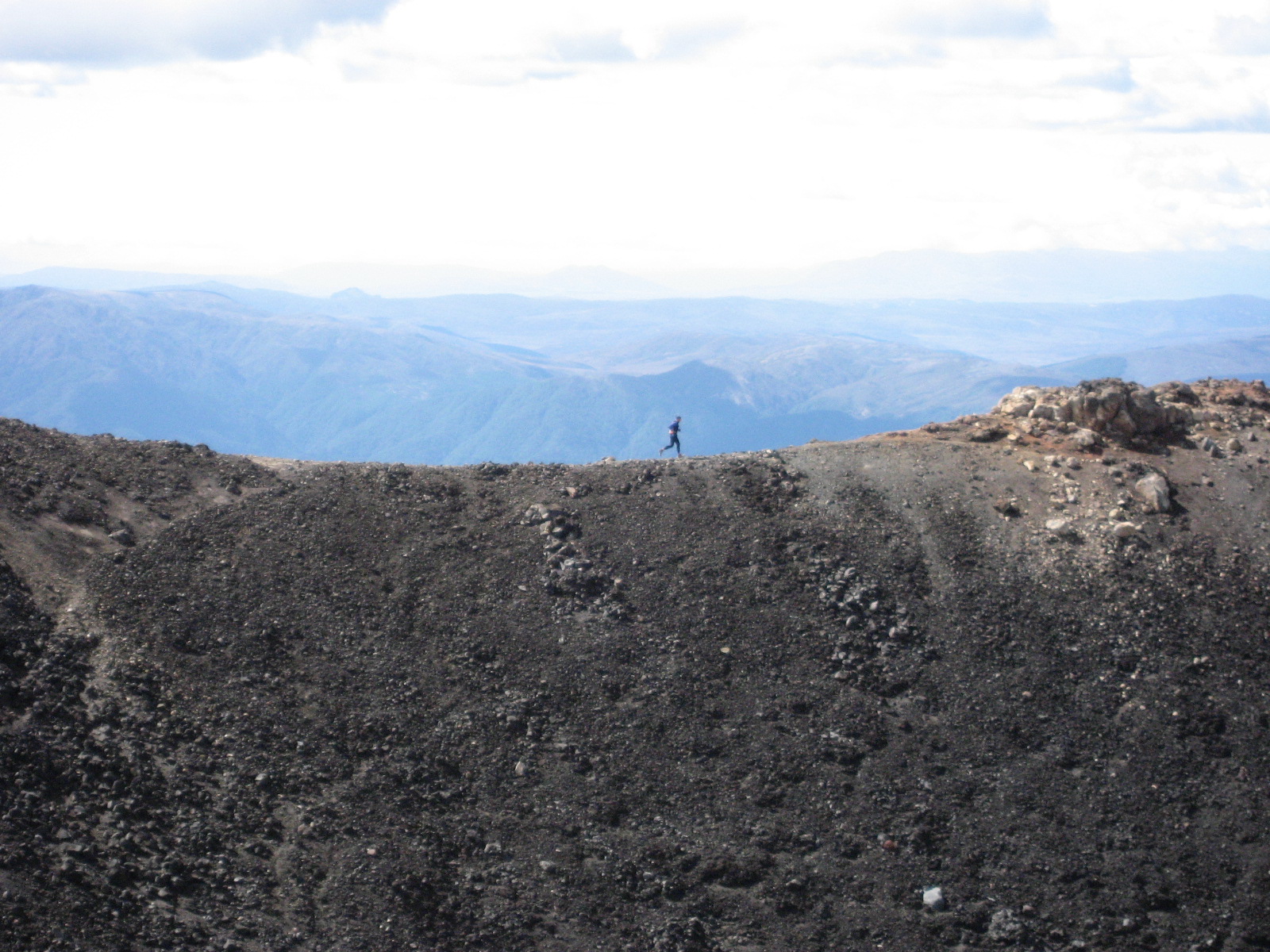 descent. Avoid getting into the big central gully which has bluffs, and loose rock -- probably best to tend (true) right to descend on the steep scree face; left is also possible but of mixed quality. At the bottom is nice running across country and over a possibly dry tarn to two low adjacent cols above the Upper Tama Lake -- pop over the left-hand col, which has a soft 60 metre descent to a remote and sheltered/bushy sandy beach by the rain-filled lake (refreshing swim on a hot day). Head left around the lake shoreline -- some obstacles can be bypassed by clambering up a few metres and/or getting wet-- then head for the obvious low saddle. From here climb up around the lake over some low hills (runable) to where you join the standard track from the Upper Tama lake. A cruisy and mostly downhill hour-long run back to the Chateau.
This classic wilderness tramp through Aspiring Natiional Park can be done as a day run, but only under ideal summertime conditions, with low rivers, no low snow, and good weather. There's a scenic 110km bike ride back to the car the next day. The 60km route passes through some awesome scenery, however it requires careful assessment of weather, route, fitness and river crossing (read Moirs Guide North, carry maps, jacket, basic survival gear, plenty of food etc). Although it is normally tramped from the Wilkin to the Matukituki, as a run/bike it also works well in reverse. Drive to Makarora: you need to leave bike, sleeping bag, and tent here and arrive with enough daylight to check out the Makarora river. Find a reliable crossing site (may be 2km or so south of the DOC visitor centre, which may advise). You need to be confident you can locate it (and the campsite) from the other side on the return, even in the dark! Drive early next morning to the swingbridge near the end of the road to Mt Aspiring that leads into the East Matukituki (or drive there the night before and bivy by the car leaving the tent back in Makarora). Start at first light and begin the long but stunning run up the remote East Matukituiki valley to Junction Flat, Ruth Flat, and follow occasional poles/cairns up over Rabbit Pass, through a delightful hanging valley which finishes abruptly as you approach the notorious 'Waterfall Face'. The descent of this steep, exposed face of grassy bluffs requires care (the first marker pole is up well out to the true left of the face), and could be particularly risky if wet (but it's going to be easier than if you had a tramping pack). Once down, at Waterfall Flat, a rough track leads through scrub above gorges before dropping down to Top Flats Hut. From here there is a long, cruisy run across open river flats and bush to Kerin Forks Hut. A km or so below the hut, find a suitable braided place to cross the Wilkin and run out the last dozen or so km down the true left of the river and tracks to the Makarora, dinner and beer. Next day it's a nice bike ride back to the car beside the lakes, and via Wanaka. Just after Gledhu Bay, it's worth tossing the tent etc into scrub by the road for later pickup so you don't need to bike it the last 40km, much of which is gravel.
(see end of this webpage)
but not quite meeting the criteria to be a true classic! Note: for these outings (except Ball Pass, Kaikoura traverse) all gear will fit in a bum bag or camelback. Those listed before Ball Pass are day trips from Christchurch. Especially good ones get a star (*)
This classic 2-3 day tramping route is a superb and straightforward summertime run in a spectacular alpine setting. From Lake Ohau drive north to the Temple valley car park. Cross the river and run up the forested North Temple valley (<1 hour) which is walled in by an impressive and forbidding cirque. In the corner (true right) is an obvious gully that leads steeply up to 'Gunsight Pass' (1900m) and which is a pleasant sustained climb, easier than it looks, with great views from the top. Descend steep but runnable scree on the south side, tending right, and further down boulder hop down the rocks that form a path between scrub in the upper valley - watch out for a marked track initially on the true right leads through scrub sections and then forest tracks and open riverbed. The South Temple hut is situated on a terrace on the true right of the valley near where the river makes a sweeping turn to the left. From the hut, it's a cruisy run out through forest back to the car. Takes about 4.5 hours. The river at the start can be uncrossable after heavy rain and the saddle can also hold snow/ice, particularly on the south side.
An in-and-out summertime run up the Hopkins river (south of Mount Cook NP), up a track through bush and onto the steep north ridge of 'Dasler Pinnacles' with great views. Drive up the Lake Ohau Road to the car park, and swap to a mountain bike, for the rest of the journey towards Monument Hut site -- ditch the bike and start running up valley, crossing the Hopkins river towards Red Hut and follow up valley (take a map) to where the track heads up through steep bush to Dasler Biv. Above the hut the trail emerges onto open tops with great views -- head for the toe of the north ridge, which is by far the easiest way up the impressive tooth-shaped Dasler Pinnacles. The ridge is steep and exposed but mostly straightforward and easy scrambling to the summit, which has superb views in all directions. Return the same way. For a shorter run, it should be possible to bike most of the way up the river, also on the true left. .
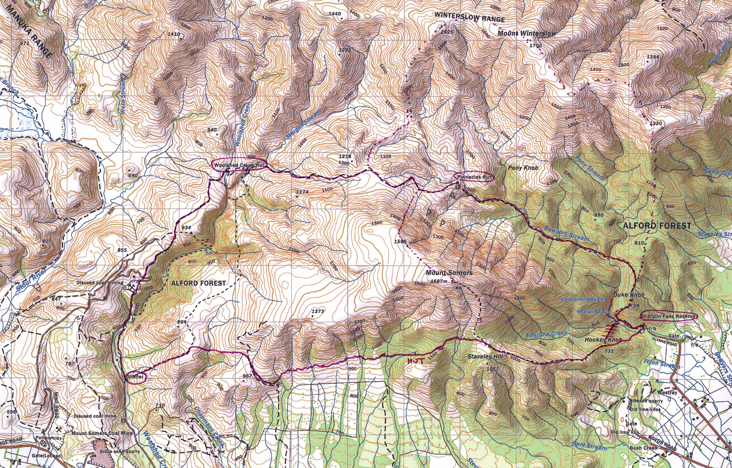 Run the Mt Somers walkway (2.20 hours) and return on the south Face track (also about 2.20 hours) -- starting and finishing at the Sharplin falls (Staveley) end. A fine mountain run, especially in autumn or spring, with varied views and terrain along the way, including good views of the Arrowsmith range, Mt Darchiac, and the sweeping Canterbury plains, forest, unusual rock formations, open tussock tops, streams, waterfalls and more. Many other variations are possible (but having run these tracks many times, the circuit described seems the best, and the Stavely end is just over 1 hour drive from Christchurch). For a shorter run you can use a bike to get back to the car. Another option (from the Woolshed creek end, and in clear weather) is to run until 1.5km before the second (Pinnacles) hut, and climb the prominent, rocky lizard-shaped spur that starts from the where track passes an obvious stream. Follow up from here through scree and small rock bands to the summit of Mt Sommers, then run south directly back to Woolshed Creek carpark -- be careful to pick up the track lower down (alternatively drop directly east from the summit on the main summit track towards Staveley Hill saddle and return via the South-Face track). A further option from Shaplin falls, is to traverse Mt Winterborn and return to the saddle for the run out along the Mt Somers walkway to Shaplin falls. Pick up the rough but clear track a few minutes beyond Duke Knob that heads off to the right..
Nice mountain run circuits, all on tracks, with no backtracking, and within 1 hour drive from Christchurch (also useful when the peaks further west are under snow). From Cooper Creek car park run up Mount Oxford (1364 metres) and follow the poled route on the open tops south that leads down back into bush where the track forks after a short climb. For a 'short' option continue directly down and back to the car via either of the two linking tracks. For longer options, at the fork on the descent, take the track that descends north-west down to Wharfedale shelter. From here you can run back on the cruisy and endlessly curving Wharfedale track, or for a bigger outing, continue down valley to the remains of the Townsend Hut where a marked track climbs 800 metres up to Black Hill hut (it's worth venturing further up onto the tops for the views). Descend from the hut 10 minutes and pick up the alternative track that drops down to the Wharfedale track, south of the Wharfedale shelter. Return via the Wharefdale track and linking tracks. This last circuit is approx. 40km and involves around 2000 metres of climbing. Take a map.
Run the Cass-Lagoon track from the Bealey end, and pick up a bike at the Cass end to get back to the car. Approx. 34km (excluding the bike ride) and two saddles but entirely runnable except for the last grunty section up to the second saddle. Plenty of water along the way. Have run this in both directions, as a run it seems best starting at the Bealey end, but starting from Cass gives a much nicer bike ride back, especially if it's north-west. If you do start from the Cass end, take care not to miss the side-stream (cairned but not well marked) that leads off from the main river up towards Lagoon saddle (take a map) -- several people have! In the other direction you can't get lost.
Many possibilities here, including:
A cruisy outing with some good views along the way. Stash bike at the Orari river road and drive to Mt Peel village. Jog up the scenic bush track to Little Mt Peel (should be water at the shelter), and then traverse along the tops arriving eventually at Big Mt Peel. From here there are great views in all directions, especially into the head of the Rangitata (pity about the transmitter station on the summit). From the summit a ridge drops steadily and steeply down into the Orari river valley. Once in the valley, follow the four wheel drive tracks (initially on the true left, then on the true right) back to the bike. There's a scenic gorge section towards the end. Cross the river sometime after the bridge, and before you reach the bikes, otherwise you'll have some interesting bluffs to negotiate. Bike back to pick up the car.
A there-and-back run up the Cameron valley (31km return) to Cameron hut which lies nestled under the spectacular rugged Arrowsmith mountains. It's a nice run (have done this 7 times) especially in autumn or early summer in clear weather. You have the sun behind you both ways, plenty of water en route, it's mostly downhill on the return, and there's a downhill bike ride and swim at the end. Feasible as a day trip from Christchurch (2 hr drive) if you start early. Park beside Lake Heron just past the houses, and mountain-bike up-valley and take a faint 4WD track that heads diagonally left (following a fence) towards the narrow Cameron valley and carpark. Just past this is a locked gate (good place to leave the bike) and run up valley on the track which stays on the true right of the river the whole way (usually on or near the riverbed, but sometimes on tracks through scrub or matagouri some of which end in tears - i.e. if in doubt head for the river). After about 55 mins or so you'll pass the old 'highland home' hut on the other side of the river, and at the end of the next long open section of valley the track climbs over a tussock hill before descending to the river again. Further up, near the obvious jumble of moraine mounds keep left, follow cairns and occasional markers up wet and dry riverbeds. A marker indicates where the track climbs up to the right and doubles back slightly over a mound to the hut which you can only see right near the end. Takes just over 2 hours or so from the gate. There is water at the hut. From the hut it's a pleasant wander further up valley on the obvious 'carriageway' or for better views on moraine wall on the opposite side of the valley; sunglasses and sunhat are useful- it's pretty bright up there, not to mention awesome scenery. Climbing the small hill behind the hut also gives a nice perspective. The return mostly-downhill run and bike-ride is fun, and you can cool off with dip in the lake at the end.
Outstanding views and an `airy' run along the top of the three peaks of Mt Binser, and carrying on with a cruisy descent down a long undulating ridge. Accessed from Andrews shelter (Mt White Rd) - but may pay to bike further up the road (or put a bike there). Jog up through the bush track to Binser saddle (grass flats) then negotiate the (untraked) bush onto the northern flanks of Mt Binser's low peak. From the summit, there is a 2km long traverse over the second and third (highest) peak. Continue in the same (south) direction along the obvious visible ridge, dropping down a steep scree face, then following an undulating ridge as it winds westerly around to the road (there is a shorter direct descent off the high peak down the west ridge). Near the bottom of the longer main ridge as it heading south-west (with scrub ahead) pick up the scree slide out to your left that drops into a scree gully that goes all the way to the road (spot it from above). Run back to the bike by the road and/or across grassy flats. Takes four hours or so, depending on sightseeing and where you put the bike.
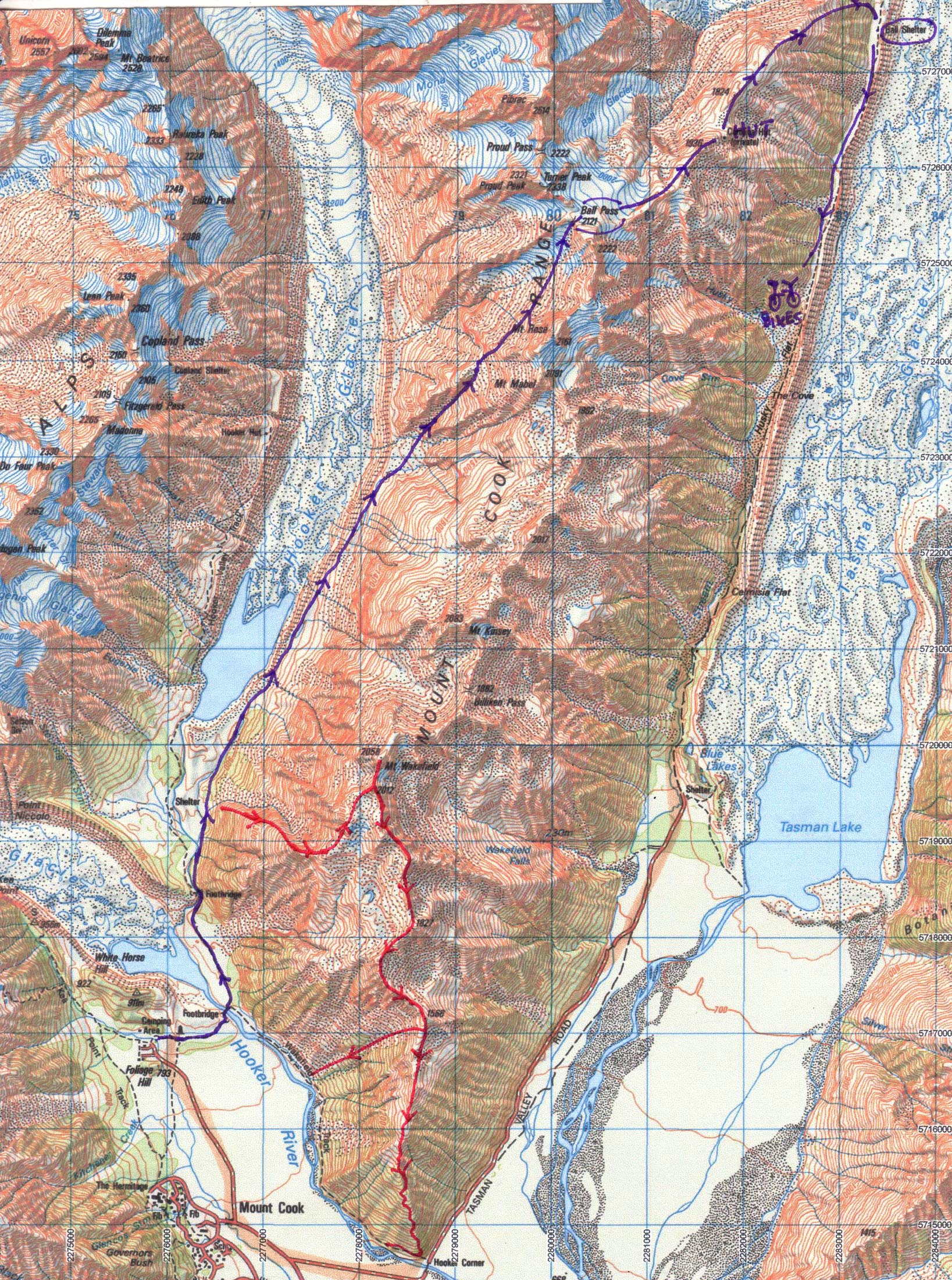 Very spectacular trip (more of a hike than a run, and as a day-trip wait till summer and clear weather; even then you'll still need to take ice axe and crampons). Drive up to Celmisia flat the night before and stash the bike somewhere up the Tasman glacier. Return to Mt Cook village. Next day set off early up the Hooker valley and head up a prominent gully (usually snow filled) then sidle up towards the pass. Drop down to the (private) hut then down to the valley and the bike. Take a map, compass, jacket and water.
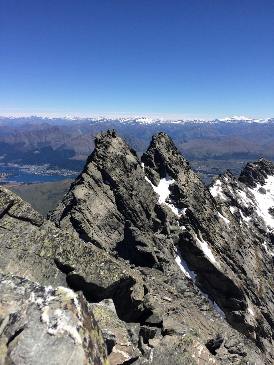 A summer-only trip taking you to the highest point on the Remarkables Range
(Single Cone 2319m) by a route that has just one slightly tricky section- a fine weather trip only.
There are various options
for this trip, but maybe the most pleasant would be to drop a bike at
Wye Creek, and get someone to drop you at the Remarkables Ski Field (I
biked from Queenstown - it's OK, but the upper gravel part is fairly
tedious). Run to Lake Alta, then follow up the Wye Creek route to the first
col. Then head up onto a pleasant ledge which you follow south a
bit. Then climb nice slabs of schist rock (possible patches of snow) and
head up towards Single Cone. High up you will see a steep snow-free solid rock gully that you
will probably arrive to the south of, but it is easy to traverse north to get to it on rock ledges
(avoiding any steep frozen snow). The gully is steep and exposed, but
there is good friction on the rock and hand-holds, and coming down is no worse
than going up. From the top it's only a few minutes to the summit, and
awesome views, but remember where the gully is (there is a prominent
cairn). Enjoy the views then return to the Wye creek route and follow
this out to the bike by the lake.
A summer-only trip taking you to the highest point on the Remarkables Range
(Single Cone 2319m) by a route that has just one slightly tricky section- a fine weather trip only.
There are various options
for this trip, but maybe the most pleasant would be to drop a bike at
Wye Creek, and get someone to drop you at the Remarkables Ski Field (I
biked from Queenstown - it's OK, but the upper gravel part is fairly
tedious). Run to Lake Alta, then follow up the Wye Creek route to the first
col. Then head up onto a pleasant ledge which you follow south a
bit. Then climb nice slabs of schist rock (possible patches of snow) and
head up towards Single Cone. High up you will see a steep snow-free solid rock gully that you
will probably arrive to the south of, but it is easy to traverse north to get to it on rock ledges
(avoiding any steep frozen snow). The gully is steep and exposed, but
there is good friction on the rock and hand-holds, and coming down is no worse
than going up. From the top it's only a few minutes to the summit, and
awesome views, but remember where the gully is (there is a prominent
cairn). Enjoy the views then return to the Wye creek route and follow
this out to the bike by the lake.
Don't expect to run too much of this, but it involves some stunning scenery, good climbing, and in summer needs no technical gear provided there has been no recent snow. Start early, don't attempt in poor visibility, take a map and plenty of water. Run up past the second Hooker valley footbridge. Continue on the east side trail for about 1km. Head across the scrub onto the southern edge of a wide basin - the route lies up the nearby ridge. To get onto the ridge, suss it out from below - you can either climb exposed slabs and/or the less exposed, but aggressive scrub to their right, or there may be other options. Above this is some excellent, sound rock. Further up a second crux (sharp gendarme) becomes suddenly obvious, but can be sidled on the north side, followed by some careful, exposed climbing over the next 50 metres of ridge. It's straightforward from here to Mt Wakefield (2058m). Return along the south-east ridge, with shortcuts possible across the basin (may be tarns or snow for water here). Follow this undulating ridge south. You can either drop off on a direct scree run all the way to the Hooker river, or follow the faint track all the way to the road bridge at Hooker corner then bike back if you don't want to use the now-closed but passable Wakefield track.
A very pleasant run in Fiordland around the well-formed Keplar track (a popular 3-4 day 60km tramping trip), taking in a long section on the tops, and plenty of forests, lakes, rivers etc. Although the complete circuit (which is run every summer as the `Kepler Challenge') is 60km, a slightly shorter (50km) and maybe more pleasant alternative is to put a bike at Rainbow Reach and cycle the last section on the road. From the control gates in Te Anau, set off at first light to avoid the crowds, and for good views on the top. After a 10km warm-up run along the lakeside forest start the long but graded climb up Mt Luxmore (1000m climb). An enjoyable tops traverse is then followed by a very fast descent down, and the long but cruisy run down The Iris Burn to the bike. You only need the basic free map from the visitor centre for this one, and there's plenty of water in the huts and streams.
Haven't done this one as a run (only as a tramp) - it would be a long trip (63 km) up the Rees river valley, over the Rees saddle and down the Dart river valley (a popular 4 day tramping trip) with a mountain bike ride back. Make sure the track is clear of snow, and there hasn't been any heavy rain for a while, and take a map. Put a bike and some 'refreshments' at Chinaman's Bluff (Paradise end) then drive to the start of the Rees end of the track to camp. An alternative shorter (33km) but fun run that I have done is the return run from Chinaman's Bluff to Daley Flat hut.
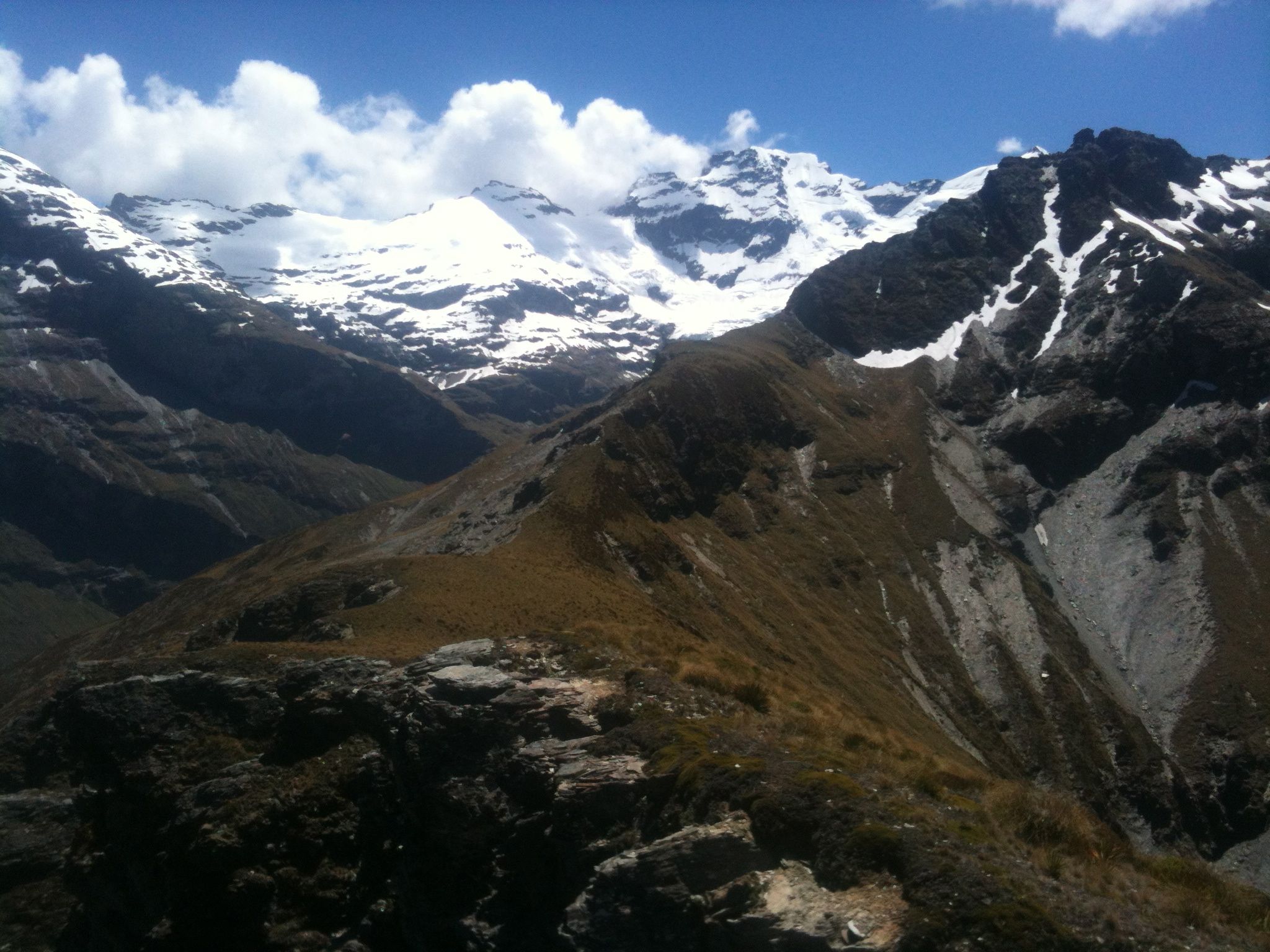 A remote 25km mountain run with superb views very close (12km) to Glenorchy. It's a circuit back to the start, mostly runnable, but with a steep section to gain the ridge. Cycle or drive up-valley and turn right at 'Lovers Leap' road (public road) 1km before the Earnslaw burn bridge and continue up to the mouth of the valley (1km) and park. Head towards the river and pick up orange markers. Run up the well-marked track (7km)
which is mostly through the bush above the river to the upper valley (500m climb). There is a a marked but easily missed huge rock biv across the river near bushline; however if you wish to keep your feet dry continue on up the true left of the river for a 2-3 kilometers on faint trails to amazing views of the falling glaciers and waterfalls off Mt Earnslaw (highest peak in the region). Return and rejoin the main track and after about 500 metres the first main stream is encountered. Head up this gaining height quickly for 500 metres then as it steepens escape onto the true left (vegetated) side and head straight up to an obvious col (steep). Don't be put off by the intimidating looking bluffs above - the ridge is fast travel once you break through onto it. Once on the ridge, head along the long, undulating ridge -- mostly tussocky with faint trails, but with occasional short rock sections thrown in -- all the way back to the point where it drops steeply down back to the mouth of the valley (avoiding most of the bush, and also the sheer bluff at the end! - have a look up as you set off at the start). If the weather packs in, it's probably safest to return back via the valley on the track.
A remote 25km mountain run with superb views very close (12km) to Glenorchy. It's a circuit back to the start, mostly runnable, but with a steep section to gain the ridge. Cycle or drive up-valley and turn right at 'Lovers Leap' road (public road) 1km before the Earnslaw burn bridge and continue up to the mouth of the valley (1km) and park. Head towards the river and pick up orange markers. Run up the well-marked track (7km)
which is mostly through the bush above the river to the upper valley (500m climb). There is a a marked but easily missed huge rock biv across the river near bushline; however if you wish to keep your feet dry continue on up the true left of the river for a 2-3 kilometers on faint trails to amazing views of the falling glaciers and waterfalls off Mt Earnslaw (highest peak in the region). Return and rejoin the main track and after about 500 metres the first main stream is encountered. Head up this gaining height quickly for 500 metres then as it steepens escape onto the true left (vegetated) side and head straight up to an obvious col (steep). Don't be put off by the intimidating looking bluffs above - the ridge is fast travel once you break through onto it. Once on the ridge, head along the long, undulating ridge -- mostly tussocky with faint trails, but with occasional short rock sections thrown in -- all the way back to the point where it drops steeply down back to the mouth of the valley (avoiding most of the bush, and also the sheer bluff at the end! - have a look up as you set off at the start). If the weather packs in, it's probably safest to return back via the valley on the track.
To Fiordland and back. A circuit trip (approx. 55km+ run, 30km bike) with spectacular views of the high Fiordland mountains, bush, lakes, waterfalls, deep valleys, and more. Place the bike the night before at the Greenstone/Caples car park and camp at the DOC campsite that's a few km before the Routeburn track. Start early (first light, or by 6am at the latest) to avoid the many walkers on the `Great Walk' Routeburn track. A pleasant run takes you past the first hut, and above an impressive alpine lake to Harris saddle (side trip to summit worthwhile), with up-close views of the glaciated Darran mountains. From here an exhilarating run above the steep Hollyford valley brings you down to the second hut by a lake. Then it's a cruisy run to the third hut, where you avoid the last few km of the Routeburn and head off on the start of the Greenstone/Caples track. The Caples track is shorter, but involves a grunty climb up to a saddle which has great views of the lower Hollyford peaks. From here it is all downhill (though a bit slow till the first hut) and a cruisy but lengthy run out down the open Caples valley. Plenty of water along the way. Alternatively, you can return via the longer Greenstone valley. Either way the bike will be a welcome sight for the return journey beside the lake to the car. Finally, if you have less time or no bike, the run up the Routeburn track to Harris Saddle and return is a good option (3.5 hours round trip).
A 53km circuit on the edge of Fiordland, with sweeping views of the ocean and mountains of south-east Fiordland, and some nice coastline and historical viaducts along the way (a popular 3-day tramping circuit). Make sure the track has dried out a bit (otherwise the mud can make slow going in places), that low tide will coincide with the coastal return, and that a storm is not about to arrive from Antarctica. Drive either to the carpark up the hill and run down the signed public track, or park lower down (in which case you can mountainbike along the beach for the first part and use it again for the return). Then follow the track which travels along the coast, before heading in an increasingly steep gradient to the turn off to the hut. It is worth taking the detour towards the hut and turning off on the obvious boardwalk up to the high rock formations, with views into the lakes and mountains of Fiordland Backtrack to the turn-off, and follow the route along the tops (much of it on boardwalk) which undulates in a gradual descent, with superb views. Eventually, after a final steep, sometimes muddy descent through bush you arrive back down near the south coast on an old railway cutting that passes over some impressive old wooden viaducts. Follow this to Port Craig (water and hut) and then take the low tide route back.
At 67km this is the second longest run listed here. It is well-formed and popular track that combines a mix of open, high country farmland, beachforest, and mountain views, with three low alpine passes and numerous huts along the way. In summer on a fine day, all gear will fit in a bum bag. Place a bike at the lewis pass end and drive back to the southern end of the track (good camp site here). There is plenty of water along the way, though it is worth filling up before the long section farmland section near Ada homestead. When you finally emerge at Lewis Pass bike back to the start (17km) along the highway (mostly downhill).
A spectacular one-day trip along the tops of the central seaward Kaikoura range, including a traverse of the highest peak, Manakau (2600m), starting and finishing in Kaikoura. This trip requiring no backtracking, but it's a very long (epic?) day, requiring at least one bike, 3100 metres of climbing and 30 km of mostly untracked terrain. An easier option is also listed below. Start before dawn, take a head torch, jacket compass, map and plenty of water-carrying capacity.
 From the beach in Kaikoura, cycle or drive north on SH1 turning into Parsons Road which leads to the Hapuku River. Run up this river (true left, then true right) to the waterfall and gorge - a track climbs around the gorge and eventually leads to Hapuku Hut (not marked on the topomap). Cross the river, head up valley, and climb up the second stream past the hut draining Mt Uwerau. Fill up with water here, then climb the rocky scree and gain a spur on your left - follow up through scrub, scree and rock to the summit of Uwerau (2200m). From here begin the 3km traverse to Manakau (2600m). The first half of this rarely-traversed section has some interesting and exposed rocky outcrops to go over or around (alpine grade 2, it is possible to stay on the ridge the whole way, but take care - an accident here would be serious). Water can sometimes be found in a stream on the flat shelf just below the ridge (north side) before the ridge rises up to the main seaward kaikoura ridgeline. From the summit of Manakau, it's a fast undulating descent (with some minor rocky sections) to a saddle infront of a steep climb (a stream is 150 metres below on the east side). Climb and head north along the easy and undulating tops, past some hanging basins towards the second-highest peak in the range Mt Te-Ao-Whakere. From a high point on the range surrounded by hanging basins and overlooking Happy Valley (south of Te-Ao-Whakere) head east to pick up a long and prominent ridge that drops down in steps eventually finishing in a scree slide into the north branch of the Jordan river (consult map!). Run down the river to pick up the bike, and enjoy the (mostly) downhill descent to SH1. Cross the Hapuku river bridge then immediately head down a shingle road to the coast, and follow it south all the way back to Kaikoura.
A shorter variation to this full traverse (requiring no bike(s)) start and finishes at the pleasant campsite at the fork of the north and west branches of the Hapuku river, a a two-hour walk up the Hapuku valley (turn off to the above track at the sign to Barrett's hut).
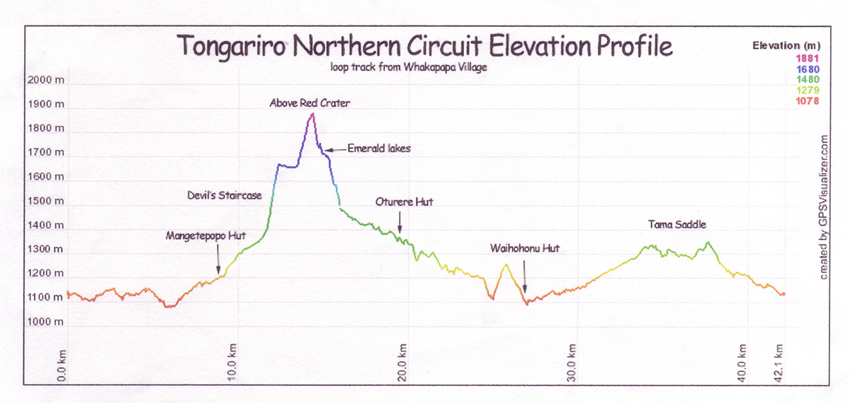 A superb run run along one of DOC's ``Great Walks'' starting and finishing at Whakapapa (37 km approx.). From the Chateau, run to Mangatepopo then up the valley, and onto and across the spectacular volcanic plateau. At Emerald Lakes turn right and descend through the lava moonscape to Oturere hut, then across pleasant open and mildly undulating terrain with a final climb through bush to Waihohonu hut. It's a long log back up to the deceptively undulating saddle near Tama Lakes. Once you see the Chateau it's all downhill back to Whakapapa. Some nice swimming holes to plunge into near the end, and plenty of water en route (three huts). Could include Ngauruhoe, Blue Lake or Tama Lake(s) if keen. Start early to avoid the Tongariro crossing crowds.
More of a hill run than a mountain run, but with good views, and within 30 mins or so of Christchurch. Good for training, and can do these any time of year; all gear will fit in a bum bag. Especially good ones get a star (*)
Get dropped off at start of track, which is near the top of the road (above a cattlestop) above Gebbies pass. Follow the crater rim all the way around the tops to Sign of Kiwi (1 hour, water) and Gondola(water?), to Evans pass and Godley Head (water) and drop down to Taylor's mistake, cross the bay and on to Sumner, and catch bus back to town. [Post-earthquake update (Dec. 2011)]: Most of this track is still OK, however a 1+km section below Mt Pleasant along to the gun emplacements crosses some slips beneath steep cliffs, though it's now well cairned. The last part of the track into Sunmer disappeared into the sea on June 13, 2011, but there is an easy alternative.
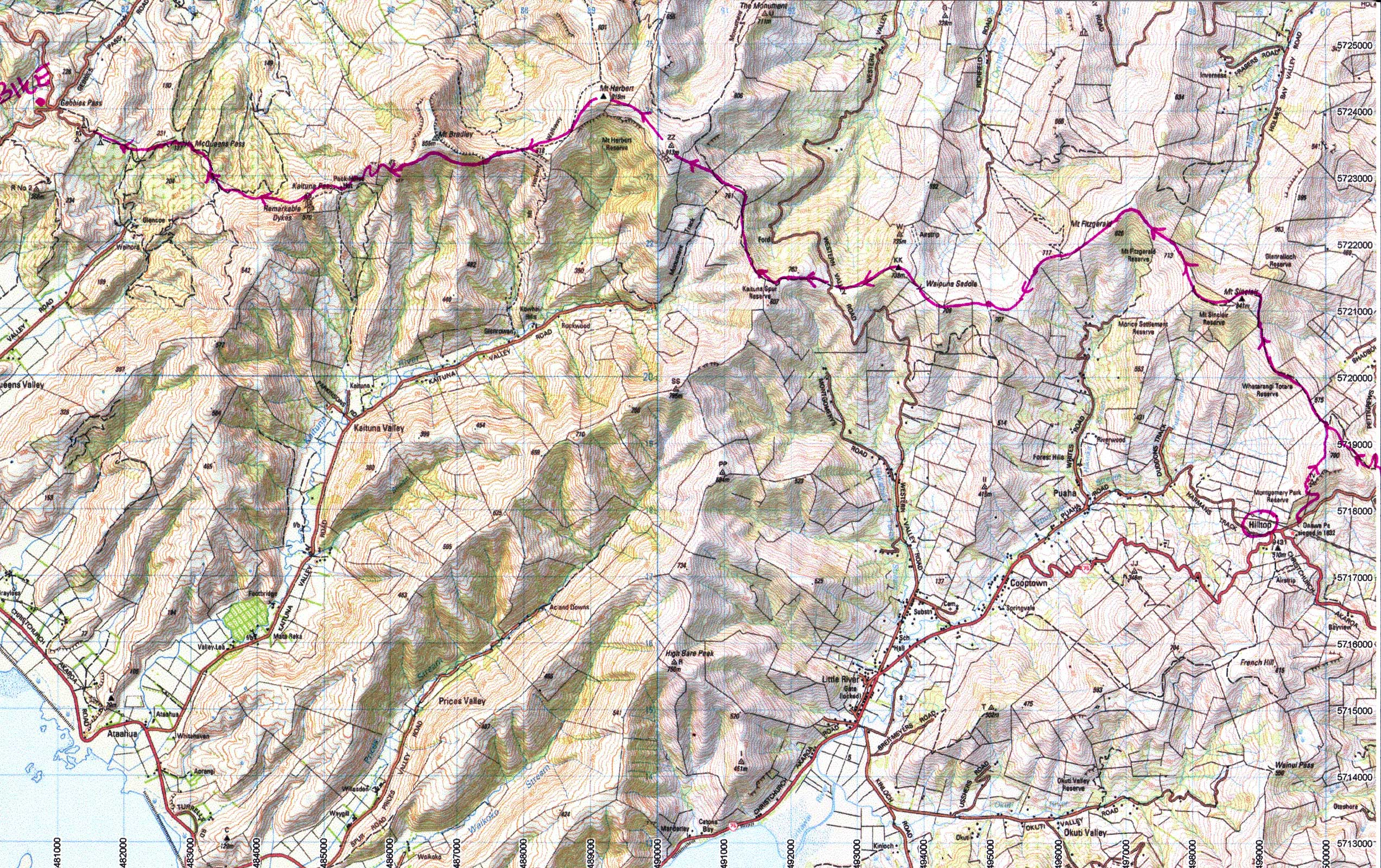 A spectacular longish trip through the central tops of Banks Penninsula. Drop bike on Gebbies pass and drive to the cafe at Taradale (where the road meets the main road to Akaroa) to pick up the shuttle bus to Akaroa -- get off at the "hilltop" ($10). Climb up through Montgomery Park (or run further along the summit road and turn left onto Pettigrews Road) and then along the tops on old tracks (``double fenceline'') as far as Mt Herbert, then follow the ridge towards to Mt Bradley to pick up the track around the southern bushy side that eventually zig zags down to Packhorse hut. From here a fast descent leads past the remarkable dykes to Gebbies Pass. Pick up a bike to get back to the car. Usually water at Mt Herbert shelter and Packhorse hut. Takes 3.5 hours.
As for (B) as far as Mt Bradley (short detour to the shelter for water) the down Bradley's long ridge to Diamond Harbour to catch the boat to Lyttelton (bike or run back over the port hills).
Drive to Diamond Harbour continue on up the big hill to stash the bike on Purau saddle. Drive back to Orton Bradley park. Run up the valley then cut up right onto the prominent ridge that leads up to Mt Bradley (gorse right near the top may be a problem). Follow the ridge top along to Mt Herbert, then down and along past the "Monument" and down to Purau saddle to pick up the bike.
A short, scenic and varied round trip over Mt Vernon, sign of the Kiwi and Mt Victoria, starting and finishing at the Bowenvale valley car park. The "challenge" part is to do this in one hour or less! From the car park, run to the end of the gravel road, then up tracks (some direct shortcuts) and more gravel road and one last direct shortcut to Mt Vernon summit (25min). Run back along the Crater Rim walkway over three small bumps and some native bush on the Lyttelton side to sign of the Kiwi (16 mins), then down the (Harry Ell) track beside Dyers Pass road; cross the road to Victoria park, and continue on the track until you meet some steep steps going down. At this point sidle right and follow a track directly up to Mt Victoria, passing by the octagonal visitor centre (9 mins) and round to the right to pick up the descent track. Head down picking up steep, dusty mountainbike trails through the trees where-ever possible - the valley floor is just 4 minutes away. Try to stay as far "down-valley" as possible, and you will eventually come out on a (once private) road, which leads back to the end of the original gravel road and back to the car park (6 mins).
Superb scenic and varied circuit - one of the best on the port hills. Park at the beach at sumner, and run up the Captain Thomas walkway to Evans Pass [the lower part of this track is passable, but officially closed], follow the crater rim walkway to Godley head; then drop north on the the fast trail to Taylors mistake. Cross (swim?) the beach and pick up the trail off the far rocks that lead up over the bluffs to end back in Sumner - takes 1.5+ hours. Also a nice run in reverse, with the long, cruisy descent at the end.
A longish, but pleasant outing on a hot day, provided the tide is low (check first). Run from Sign of the Takahe to the Sign of the Kiwi then along the crater rim walkway to the Bridle Track. Drop down into Lyttelton and keep heading down and right, past the sports field (watertap by sports pavillion), past the yacht marina, and pick up a track that leads round to Corsair bay (good swimming). Ten minutes past Cass Bay the track makes an unexpected zig-zag scent --if the tide is high take this, and ascend the prominent steep ridge/face above Rapaki to get back. Otherwise drop steeply down to the sea by the fenceline, and follow the sometimes remote coastline all the way around to Governors Bay. Quite a bit of boulder hopping, interspersed with short sandy sections, shellfish, and rocky shoreline, and a couple of short steep scrambles if you want to avoid swimming. Pick up a track that goes around to the jetty, then up to the main road. The most direct track up to the crater rim walkway leaves the main road just north of here (alternatively, go south to Ernest Adams drive, take the "private" road up to a gate, past a watertank, to pick up a track). Either way it's a fast descent from the top back to the start.
A short, scenic side trip from the Crater Rim walkway. Between the Rapaki rock car park and Mt Vernon, descend the main, increasingly steep ridge towards Rapaki Bay. Drop right to avoid bluffs at the base -with one hand on the base of a helpful flax bush, you should be able to find ground in the upper Rapaki valley. Traverse around the valley without dropping too much, and start up the edge of the prominent face. Short sections of rock scrambling can be contrived and further up you can move left onto the face for more adventure. Good view from the top, then follow faint trails along the top, tending to the right side of the ridge, to eventually pick up the Crater Rim walkway over the fence.
Bike up Broad Oaks/Huntsbury to end of seal. Run up the trail in the fields just right of the gravel road, cross a fence and carry on across the 'airstrip' and up and over Mt Vernon. Head along the crater rim walkway to the Gondola (drinks available, at a price) and continue on the crater rim trail through bush on the Lyttelton side (slow going) to the gun emplacements. Then head cross country to pick up a mountain bike track that goes right to the summit of Mt Pleasant. Drop off the summit to eventually pick up the same track for a short while, then head left cross-country to descend some low bluffs and to rejoin the crater rim track. Follow this back to the top of Rapaki track -- instead of going down this track sidle around the other side of that valley on faint sheep trails through tussocks, keeping a roughly constant height (surprisingly runnable) for a couple of km until the hills sweeps round to the west. Climb slightly over a low saddle and descends to a popular 4WD/MTB track below the ridge that leads down to Albert Terrace. Don't descend more than 100m or so, looking out for an odd metal structure in the valley below you, and drop steeply down to this, then drop down to the valley floor and regain a trail that leads back to the bike.
A scenic there-and-back run (2-2.5 hours) along the western section of the Crater Rim walkway. Start either from sign of the Takahe (Dyers Pass Rd) or the end of the seal on Worsley's Road (closer). Run up the appropriate track to the summit road and pick up the Crater Rim walkway. This has some pleasant bush sections on the Lyttelton Harbour side (the prominent outlying crag 2mins off the track after sign of bellbird makes for an airy viewpoint and scramble), then an open traverse of undulating tops leading to the prominent rocky outcrop (`Cooper's Knob') which has splendid views of the harbour from the trig at the top. Returning you can get onto the road below Cooper's Knob to find water at Rhodes Spring (either by continuing on the track south or more directly by returning north by 200 metres to take a path that leads down to the summit road). After the spring you can pick up the track again at various places further along. Just after Sign of the Bellbird you can also take the western track which joins back with the Crater Rim walkway. Return back to the car/bike.
At just over 920m, Mt Herbert is the highest point on Bank Peninsula. There are several standard routes up it, all runnable, but somewhat monotonous. However the following route has plenty of variety, adds in Mt Bradley (the second highest summit) involves on backtracking, and starts and finishes at the trail head for the Packhorse hut in Kaituna valley. First drop a bike at the head of the Kaituna valley (car park/turning area) then drive back the 6k to the Kaituna trail carpark. Run up the popular track to Sign of the Packhorse Hut (<30 mins, water there), and follow the marked but not widely-used track that leaves the hut and heads NORTH around the side of Mt Bradley (don't take the other track east -- you'll join it later!). The north track is mostly level and goes through an interesting bush section which crosses a stream, and later climbs up for a while. When it starts to head down, leave this track and sidle/climb up towards a skyline ridge (it rises up from left to right with a couple of prominent buttresses in it and bluffs on the right). Don't expect to be running at this stage. Head for the buttresses, the first can be easily climbed on the right side (look for cairns) and the second is most easily climbed by first heading right slightly, at which a window of sky below a wedged rock appears -- climb through this window, and then onto the top of the rock and head up (this route is aptly-called `eye of the needle' route!). For a minute or two you can believe you are on a real mountain, but then you arrive at a large flat, gorse-infested table-land not much lower than the summit. Fortunately someone has recently cut a trail through this miserable mess (April 2017) so you can get to the summit without getting seriously scratched (if you loose the track it's probably on your right!). From the (indistinct) summit, now head south a little and then drop down onto the well-marked track that is high up on the south side of Mt Bradley - there's no trail down, just sight the track from above and find a gorse-free route to it! From there, the track is straightforward and pleasant, if slow, running through native bush, then across the fence and up to the Mt Herbert Shelter (water here too hidden behind the shelter, also toilet). Carry on the last bit up Mt Herbert, and on along the undulating ridge (nice running, great views) to the next bump (913 m) after which a pleasant and long tussock descent brings you to the Monument north track. DON'T take this. Instead carry on along the main walkway just to the right of pt 761 until you come to the sign for the Monument South track -- this leads you down 3.6kms on very cruisy farm trails with nice bush at the bottom, and a homestead, to the bike (this is all on public land and access is no problem). Round trip is about 18km or so, and it's mostly runnable except for the steep section up Mt Bradley. Don't do this trip in reverse!
A famous circumnavigation trip, high above the Stubai valley with varied sweeping views of glaciers, lakes, peaks, meadows, sheep with bells, and the valleys below. Normally walked over 4 or 5 days, this spectacular route lies mostly between 2200m and 2900 m and can be run in a long day in good weather, but it's a big day out - 55km and around 4000 metres of ascent/descent. Certain sections are rocky and better fast-walked than run - everyone else on this popular trail will be equipped with the obligatory pair of leki poles, staunch boots and a big pack; with the early start and alternative routes mentioned, you'll pass most of them around Dresdner Hut or in the section after the next hut.
Stay in the pleasant Austrian town of Neustift which has plenty of accommodation (Hotel Angelika is nice; also a camping ground) and is connected to Innsbruck by hourly buses (50 mins, 5 euro). Arrange for a taxi (22 euro, 2006) to pick you up no later than 5.30am to drop you at Nuernburger Hut car park (ensure you can escape early from your guesthouse). Follow the route that that is well-described in Lonely Planet's `Walks in the Alps' (taking a photocopy with you is useful in a couple of places! The cheap map widely available in the town is less helpful). Take the two alternative variations mentioned between Nurnberger and Dresdner huts; neither is technical despite being listed as `nur fur geubte', they are spectacular, and the first is also shorter than the main trail. You pass numerous high huts along the way, most of which have restaurants that serve soup, hot food, and refreshing cold drinks such as apfelshoelle. Neue Regensburger Hutte could be a good place for lunch (if tired or weather turns to custard then descend from here to the valley and bus back to Neustift). However the best sections for trail running are still ahead -- eventually you reach the final hut (Starkenburger) high above your hotel of choice in Neustift which you get to by a fairly staunch 1245 metre trail descent (or put a mountain bike in place to ride down the road). Carry sunblock, a camelback, snacks, and cash to buy food. The sustained sections of rocky trail can be hard on the soles of your feet, so some additional cushioning may be useful.
The Watzmann (2713 metres) is an imposing and famous mountain in the German alps near Austria - it is the highest peak in Germany outside of the distant Zugspitze group. The mountain has three summits connected by an interesting ridge, with the big `Ostwand' (east face) dropping sheer towards the fiord-like lake Konigsee below. Take the train to Berchtesgaden, which is very near the Austrian town of Salzburg. Preferably hire a bike, otherwise it may be a good idea to arrange an early taxi. In either case, head out early to the parking spot at Wimbachbrucke, hike up to the hut (Watzmannhaus) and head straight up the obvious ridge (rather than the zig-zag trail to its right) until a steep section before the first summit may require a slight detour onto the trail (the trail is always well-marked with red-white dots on rocks). This first summit (Hocheck) is where many people turn around, however the ridge to the middle (high) and on to the south summit is easy rock scrambling on the ridge, with some traversing around obstacles on the west side. There are a couple of `airy' sections, especially descending off the high peak, though any difficulties are well protected by fixed cables (no gear is needed, but would be tricky if wet or windy -- it's a fine-weather, summer trip). From the south summit follow the marked trail that drops off steadily into the Wimbachtal valley. From here it is a very pleasant, scenic and cruisy run out, gently descending this valley for about 10km on dry riverbed and tracks, and back to where you started 5-6 hours ago at Wimbachbruck. Bike back, or wait for the RVO bus every 1-2 hours. An alternative mountain run in this area would be the 3-day hike described in Lonely Planet's Walks in the Alps.